


What's New
Thank you for using our app!
This version fixes small bugs.
About Pendeli topoguide Android App
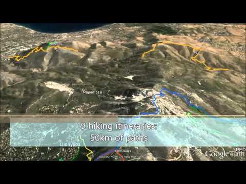
Mt. Pendeli topoguide is a digital field guide for hikers, bikers and off-roaders. It includes routes, descriptions and photos for 13 hiking and mountaineering trails, 6 mountain bike (MTB) routes, 1 trail running route (Penteli Trace), which spread throughout Mt. Pendeli (or Pedeli) near Athens, Attica, Greece. The 20 routes cover the whole Mt. Pendeli mountain range and the adjacent mountains, Mt. Agriliki and Mt. Mavrinora. Each Adventure has a description, photos and a POIs list.
Mt. Pendeli, although heavily damaged by the quarrying activities and repeated forest fires, maintains many interesting cultural and natural spots and offers many opportunities for sports and exploration to the inhabitants of Athens. Mt. Pendeli topoguide helps people looking for outdoor activities select the best suitable route and guides them along it safely.
The application offers detailed offline maps and an extensive introduction on geography, geology and the nature of Mt. Pendeli, as well as dozens of photos on all aspects of the mountain history, landscape and life. The application offers also a useful list of POIs with a comprehensive search engine.
The trails list includes easy walks, easy and moderate hiking trails and long mountain traverses, of a total length of 64 km.
The MTB routes cover all levels of difficulty and sum a total length of 85 km.
The off-road routes sum 37 km and include a quiet proposal for simple SUVs, a more demanding route for genuine 4x4 vehicles and a hard way for tuned off-road monsters.
In the field, the app identifies the nearest adventure, guides you to it and then along it by displaying messages and warnings on every junction or other important location. On each Point of Interest, photos and texts are displayed on the map. If the hiker gets off-trail, the app indicates the shorter way to get back safely.
The cartographic company AnaDigit, developer of the application, has issued previously detailed hiking maps at various detailed scales for Greece (eg. maps of Crete, Zagori, Sifnos, Naxos and other Aegean islands). To build the application and ensure the necessary data accuracy, all routes on Mt. Pendeli have been recorded and photographed during 2015.
Other Information:
Download
This version of Pendeli topoguide Android App comes with one universal variant which will work on all the Android devices.
All Versions
If you are looking to download other versions of Pendeli topoguide Android App, We have 1 version in our database. Please select one of them below to download.


